


STERLING TWP Voting District, Wayne County, Pennsylvania
About
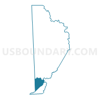
Outline

Summary
| Unique Area Identifier | 664347 |
| Name | STERLING TWP Voting District |
| County | Wayne County |
| State | Pennsylvania |
| Area (square miles) | 27.23 |
| Land Area (square miles) | 27.00 |
| Water Area (square miles) | 0.23 |
| % of Land Area | 99.15 |
| % of Water Area | 0.85 |
| Latitude of the Internal Point | 41.33324980 |
| Longtitude of the Internal Point | -75.40652820 |
Maps

Graphs
Select a template below for downloading or customizing gragh for STERLING TWP Voting District, Wayne County, Pennsylvania


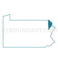
Neighbors
Neighoring Voting District (by Name) Neighboring Voting District on the Map
- CLIFTON TWP Voting District, Lackawanna County, PA
- COVINGTON TWP Voting District, Lackawanna County, PA
- DREHER TWP Voting District, Wayne County, PA
- GREENE TWP Voting District, Pike County, PA
- LEHIGH TWP Voting District, Wayne County, PA
- MADISON TWP Voting District, Lackawanna County, PA
- SALEM TWP Voting District, Wayne County, PA
Top 10 Neighboring County Subdivision (by Population) Neighboring County Subdivision on the Map
- Salem township, Wayne County, PA (4,271)
- Greene township, Pike County, PA (3,956)
- Madison township, Lackawanna County, PA (2,750)
- Covington township, Lackawanna County, PA (2,284)
- Lehigh township, Wayne County, PA (1,881)
- Clifton township, Lackawanna County, PA (1,480)
- Sterling township, Wayne County, PA (1,450)
- Dreher township, Wayne County, PA (1,412)
Top 10 Neighboring Place (by Population) Neighboring Place on the Map
Top 10 Neighboring Unified School District (by Population) Neighboring Unified School District on the Map
- Wallenpaupack Area School District, PA (25,535)
- North Pocono School District, PA (20,809)
- Western Wayne School District, PA (19,292)
Top 10 Neighboring State Legislative District Lower Chamber (by Population) Neighboring State Legislative District Lower Chamber on the Map
- State House District 139, PA (67,006)
- State House District 115, PA (63,002)
- State House District 112, PA (61,228)
Top 10 Neighboring State Legislative District Upper Chamber (by Population) Neighboring State Legislative District Upper Chamber on the Map
Top 10 Neighboring 111th Congressional District (by Population) Neighboring 111th Congressional District on the Map
Top 10 Neighboring Census Tract (by Population) Neighboring Census Tract on the Map
- Census Tract 1129.02, Lackawanna County, PA (6,182)
- Census Tract 9509, Pike County, PA (4,441)
- Census Tract 9612, Wayne County, PA (4,271)
- Census Tract 9613, Wayne County, PA (2,862)
- Census Tract 9614, Wayne County, PA (1,881)
Top 10 Neighboring 5-Digit ZIP Code Tabulation Area (by Population) Neighboring 5-Digit ZIP Code Tabulation Area on the Map
- 18436, PA (13,853)
- 18444, PA (13,778)
- 18424, PA (5,613)
- 18426, PA (4,526)
- 18445, PA (2,329)
- 18463, PA (199)